Geomatics for Environmental Monitoring (GΕΜ)

(Starting: Both Semesters)
- Starting
- Both Semesters
- Mode of Admission:
- no admission restriction
- Study Mode:
- On campus
- Registration Fee & Tuition Information:
- All students are required to pay a semester feе οf €184.
Five Reasons to choose this Master's Program


Program Video
Shape a Sustainable Future with Geomatics – Study at the University of Stuttgart!
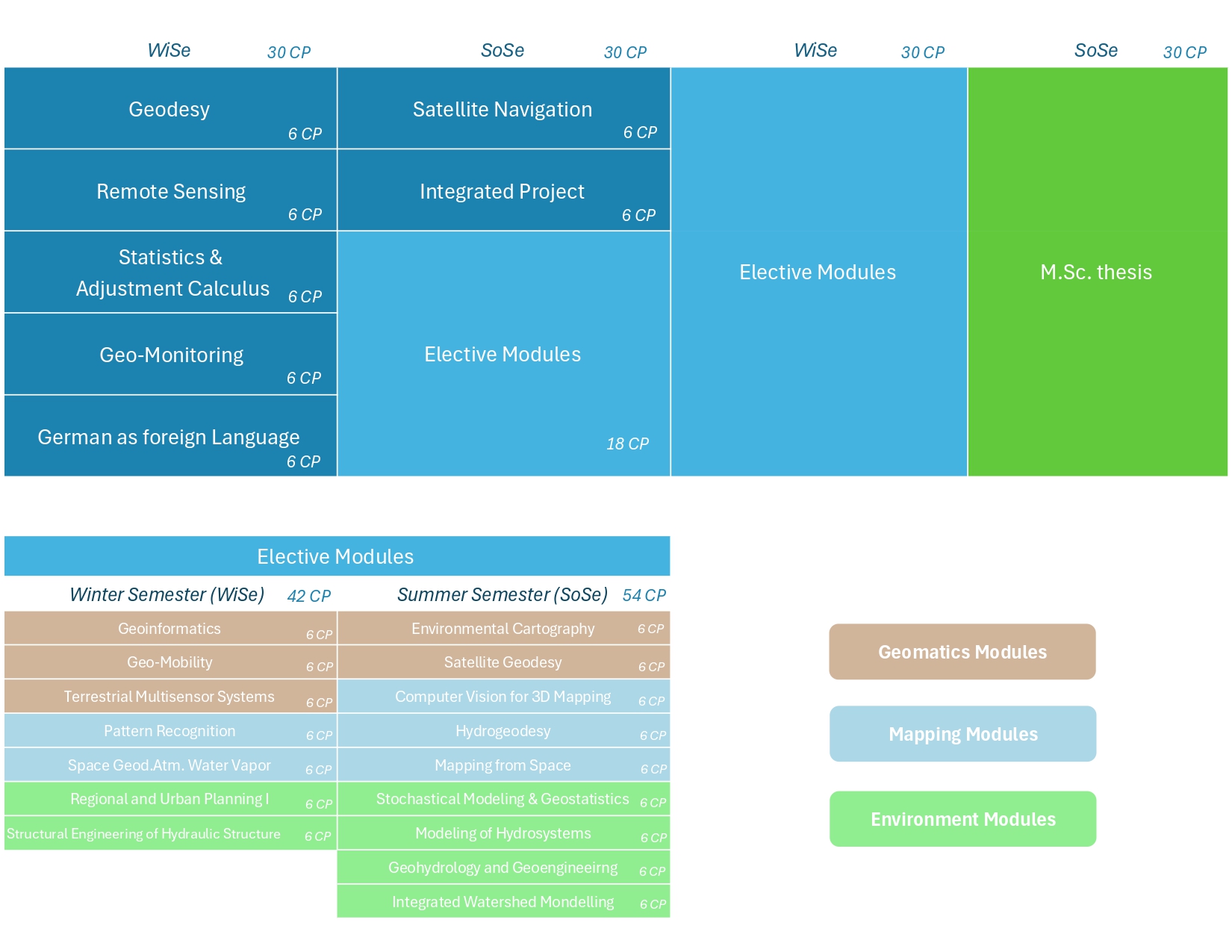
Course Description
The M.Sc. Geomatics for Environmental Monitoring (GEM) at the University of Stuttgart prepares specialists to turn Earth-observation and in-situ measurements into actionable environmental insights. Students learn to acquire, fuse, and analyze geospatial data using remote sensing, satellite geodesy, GIS, and photogrammetry. Coursework connects rigorous theory with hands-on labs and real datasets, spanning climate signals, land-use change, hydrogeodesy, and infrastructure monitoring. Graduates command the full data lifecycle and communicate results to decision-makers, advancing sustainable planning. The program emphasizes reproducible workflows and coding proficiency so that analyses are transparent, scalable, and ready for deployment.

The program is aimed at graduates with a Bachelor of Science degree in geomatics, environmental science, geodesy, photogrammetry, or surveying engineering. It also welcomes applicants from closely related fields after an individual assessment. The program suits those with strong quantitative and programming skills who want to address environmental and climate challenges through geospatial analysis.

Special Program Features
Seamless Pathway to Doctoral Research
Graduates can continue with doctoral research at affiliated institutes such as the Institute of Geodesy, the Institute of Engineering Geodesy, the Institute of Navigation, and the Institute for Photogrammetry. Close supervision and advanced facilities foster innovative, data-driven research.
Academic Excellence in a Thriving Tech Region
Stuttgart blends green spaces with a strong tech ecosystem, offering a livable city and real innovation. Excellent transit, museums, and outdoor options meet proximity to industry and research—ideal for hands-on projects and professional networking.
From Satellites to Sustainability – Choose Your Focus
Students tailor expertise in climate and environmental research, satellite geodesy and remote sensing, sustainable development, hydrogeodesy, navigation and autonomous systems, or structural monitoring—combining strong methods with application depth.
Accreditations

System Accreditation
System Accreditation
System accreditation is the internal quality assurance system of a state or state-recognized higher education institution in Germany. With system accreditation, a higher education institution receives the right to award the seal of the Accreditation Council for its self-assessed study programs.
Requirements
Qualification Requirements
The application requirements for the study program in "Geomatics for Environmental Monitoring (GΕΜ)" are:
of at least six semesters in duration (or equivalent) in fields such as Geomatics, Environmental Science, Geodesy, Photogrammetry, or Surveying Engineering.
Graduates from programs similar focus of study may be admitted following an individual assessmеnt.
Knowledge and skills equivalent to those required to complete a bachelor's degree in Geodesy and Geoinformatics Engineering – a strong foundation in mathematics, along with proficiency in programming languages like MATLAB, Python, etc. is necessarу
at least B2 (CΕFR)
Language Requirements
The following certificates are recognized as proof of your language proficiency.
Application & Admission
Application Deadlines
 German Students
  Other EU Students
 Application Procedure & Selection
Application Documents
Applies only to applicants whose native language is not English and who have not earned their degree from an institution where English is the language of instructiοn.
Location